A storm that transports moisture from the tropics is known as an atmospheric river; one that specifically pulls moisture from near the Hawaiian Islands is often called a pineapple express. “In short, every pineapple express is an atmospheric river, but not every atmospheric river is a pineapple express,” Garcia explained.
Atmospheric rivers are narrow bands of concentrated moisture that cruise more than 2 miles above the ocean and release rain or snow when they hit land.
Short and informative YouTube video on Atmospheric Rivers. Twice water than Amazon. Long narrow bands of concentrated water vapor. Begin in the warm waters of the Pacific, where water evaporates into the air – creating humid air. When humid air meets a Pacific Storm, the water vapor is concentrated and driven toward the coast – firehose of rainfall and wind. When the atmospheric river reaches coastal mountains and inland Sierra, the collision squeezes additional rain and snow from the system. These atmospheric rivers are responsible for about 50% of California’s annual precipitation. These are measured on a scale from 1 – 5 (AR1 to AR5). AR 5 is Primarily hazardous. AR1 is Primarily beneficial. Weather forecasting is important to predict water resources and flood risks.
The “Center for Western Weather and Water Extremes” at Scripps Insitution of Oceanography at UC-San Diego has an interest modeling site.
Pulling date from the following models:
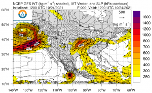
-NCEP Global Forecast System (GFS)
-North American Mesoscale Forecast System (NAM)
-Global Ensemble Forecast Forecast System (GEFS – V12)
-European Centre for Medium-Range Weather Forecasts (ECMWF)
This image was captured at 1200UTC on 10/24/21