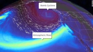
As of 20211024, there is rain up north in The Bay Area of San Francisco, heading south past Fresno, should arrive in Central Coast CA around midday (30%), and then through tonight (Sunday) 90% and then definitely 100% on Monday. I’m hearing of expressions, which are new to me – “Pineapple Express” and “Bomb Cyclone”.
Components/terms to review:
Three Storms/Systems – back to back (with the largest being the third) in Bay Area, CA
Bomb Cyclone
Atmospheric River (Large, Powerful Storm)
Pineapple Express (pulls in moisture from the tropics – “copious amounts of moisture emanating from near Hawaii”). Info from NOAA on the Pineapple Express
Low Pressure System
Warm Front
Heavy Winds
Pacific Cyclone
Weather models (long-term forecasts) – National Weather Service

Info from NOAA:
https://www.wrh.noaa.gov/total_forecast/getprod.php?new&pil=QPS&sid=LOX&wfo=lox
 A powerful early season Pacific storm system will bring an
 increasing chance of rain to the area tonight.
It will be dry through tonight, then an approaching warm front will
 bring an increasing chance of rain mainly to SLO County through the
 day on Sunday.

 A storm system is still on target to move through southwest
 California Sunday night and through Monday evening. Still on track
 with previous thinking for rainfall totals. For San Luis Obispo and
 Santa Barbara Counties, expecting between 1 and 3 inches, with the
 higher end of that range focused around the Santa Lucia range.

